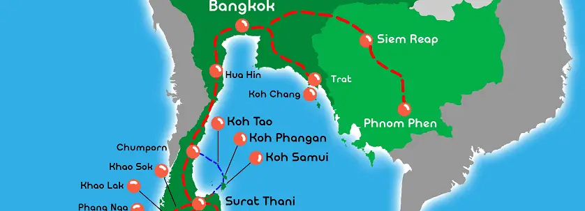
Are you wondering where is Koh Phangan on the map? Where the island is in Thailand? Where is the location in regards to Asia and the rest of the world?
Located on the Gulf of Thailand, south of the country, Koh Phangan is halfway between Koh Tao and Koh Samui; two equally popular tropical destinations.
Where Is Koh Phangan On The Map in Thailand, Island & World Location
While the island doesn’t have its own airport, it relies on the efficient ferry network that takes travellers around the islands. Most of the island is made up of granite, but its interior is comprised of dense green jungles while the coastlines are characterised by stretches of white sand beaches. There are more than 20 famous dive sites nearby.
Haad Rin and Thong Sala are the primary disembarkation points. Both of these places are equipped with complete tourist amenities, including banks, ATM’s, convenience shops, boutiques, money changers, and much more. The main police station is found outside of Thong Sala.
When researching where is Koh Phangan, you’ll also want to know about transportation. The main way of getting around here is the songthaew, which is the local version of a taxi. It is essentially a converted pickup truck that transports people through hilly roads. Private taxis, motorcycles, and jeeps can also be rented out. Some parts of the island are very hilly and don’t have very good road conditions, so travelling by yourself on a motorbike isn’t always recommended.
The two most popular and convenient ways to get here is to fly, either through the Koh Samui Airport or the Chumphon Airport. From here, you’ll then have to take land transfers to the pier to hop on a ferry that will take you to Koh Phangan.


Do You Have a Question to Ask?